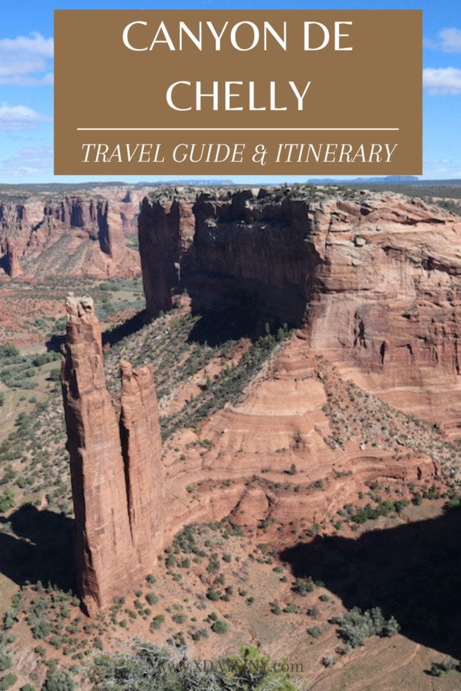
Canyon de Chelly Travel Guide & Itinerary
Mysterious cliff dwellings, spectacular monoliths taking to the skies, and a rare opportunity to connect with Native Americans from the Navajo tribe on their quest to preserve their ancestral land. In this Canyon de Chelly travel guide and itinerary, we’ll explore how to experience these thrilling highlights on a visit to one of the Southwest’s finest gems.
Ya’at’eeh! Welcome to Navajo Nation. I finally made it to Canyon de Chelly as part of an extensive five-week road trip in the American Southwest. On previous visits to the region, I had only made it so far as Monument Valley, so the visit to Canyon de Chelly was one of the most coveted stops on the long voyage. This travel guide and itinerary is based on my experience and extensive research.
Why Visit Canyon de Chelly?
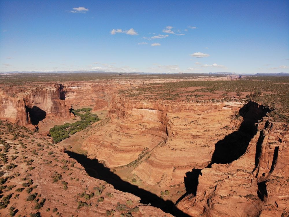
Visit one of the Southwest’s most magnificent canyons, highlighted by the stunning symmetry of Spider Rock and scenic viewpoints on the rim drives.
Witness impressive miniature cities built by Ancestral Puebloans on the canyon floor and on seemingly impossible-to-reach ledges high above.
Seize the opportunity to explore the canyon floor with a knowledgeable Navajo guide to reach the best spots and learn about the ins and out of Navajo life.
Several sections make up this travel guide:
- Background and a brief history
- Canyon de Chelly planning tips
- Canyon de Chelly itinerary: up to two days
Additional Arizona Travel Resources
Check out additional Arizona and Southwest USA travel guides to combine your visit to Canyon de Chelly with additional desert highlights.
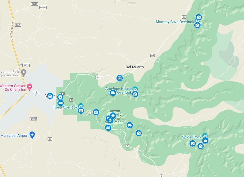
Canyon de Chelly Itinerary Map
All places mentioned in this travel guide and Canyon de Chelly itinerary are marked on this companion map. Simply click on the image to open it in Google Maps.
Background
Canyon de Chelly (pronounced “de-shay”) was named by the Spanish, who took it after the Navajo word for canyon (tseyi). It lies within one of the most continuously inhabited regions in North America. Canyon de Chelly is part of the Navajo Nation. While the national monument is jointly managed with the National Park Service, the Navajo are responsible for preserving this magnificent land.
The area encompassing Canyon de Chelly National Monument was designated as a unit of the National Park Service in 1931. However, its origins date millions of years ago when nature’s forces uplifted the land and water shaped it to its present shape. The national monument comprises Canyon de Chelly, the neighboring Canyon del Muerto, and the smaller Monument and Bat Canyons.
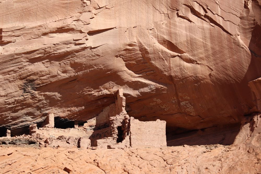
The area’s first residents were the Ancestral Puebloans, also known as Anasazi. These tribes are primarily remembered for the impressive cliff dwellings constructed on the canyon floor but often on small ledges high above the ground. At some point, the Anasazi mysteriously disappeared from the region, later “replaced” by Native Americans from the Hopi tribe who cultivated the canyon floor only to eventually leave the area in favor of more defendable dwellings on mesa tops.
The Navajo moved into the canyon after the Hopi, as they settled the Southwest between the four sacred mountains. In the 19th century, the canyon’s peace was shattered by bloody skirmishes with invading Spanish and, later, American forces. The Navajo were eventually forced to surrender and leave their homes, culminating in the traumatic Long Walk to New Mexico in 1864. Finally, in 1868, peace was achieved, and the Navajo returned to their lands in Arizona.
Today the Navajo continue the tradition of their ancestors by cultivating the canyon floor and keeping old traditions alive. Several families live inside Canyon de Chelly, razing cattle and growing various crops.
Canyon de Chelly Travel Tips
This section deep dives into the essential ingredients for a successful visit to Canyon de Chelly.


Where is Canyon de Chelly?
Canyon de Chelly is located within Navajo Nation territory in northeast Arizona. Chinle is the nearest town to the national monument. The small city of Moab in Utah is 200 miles north of Canyon de Chelly, the Grand Canyon is 220 miles west, and Monument Valley is 90 miles northwest of the canyon.
How to Get to Canyon de Chelly?
A visit to Canyon de Chelly is usually a part of a road trip so getting to the canyon depends on where you’re coming from. The visitor center is located at the junction of Routes 7 and 64.
If you’re driving to Canyon de Chelly from Moab, head south on Highway 191 to Chinle. Worthwhile detours include a visit to Four Corners National Monument and the “scenic loop” beginning from Highway 191 west along Utah State Route 191, then south on Utah SR 261 (the Moki Dugway Scenic Backway), and finally back to Highway 191 via Highway 163. Alternatively, spend one at Mesa Verde National Park and drive to Chinle via the Four Corners.
If you’re driving to Canyon de Chelly from the Grand Canyon or Monument Valley, take Navajo Service Road 59 just after Kayenta to reach Highway 191. There isn’t much to see on this stretch beyond the empty desert.
If you’re driving to Canyon de Chelly from Flagstaff, there are three worthwhile options.
- Take Arizona State Route 87 to Highway 191 and in Ganado, stretch your legs at the historic Hubbell Trading Post.
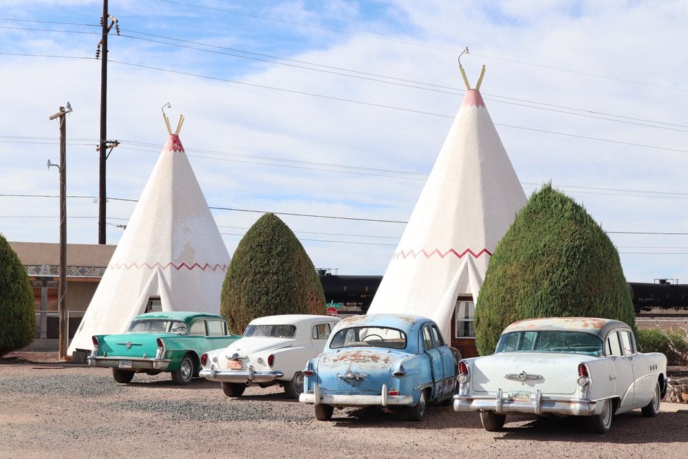
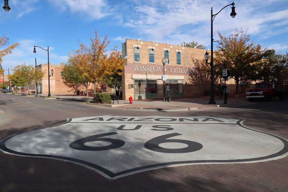
- Take Interstate 40 and stop at (the overrated) Meteor Crater. Then continue to Winslow to snap a photo at the famous Standin’ on the Corner intersection and finally at Holbrook for some “Route-66’ish” vibes at the Wigwam Motel and the Navajo County Historical Society. Then, if there’s time and you’re not in a rush, spend the day at Petrified Forest National Park and arrive at Chinle in the evening.
- Take the backcountry route and explore the Hopi tribe’s ancient mesas along SR 264, the most impressive of which is Walpi (guided tours only).
See the final section of this Canyon de Chelly travel guide and itinerary for more detail.
When is the Best Time to Visit Canyon de Chelly?
The best time to visit Canyon de Chelly is in late spring and early fall, when the daytime temperature is bearable and the nights aren’t extremely cold as they are during winter and early shoulder seasons.
Canyon de Chelly’s desert location and 5,500-foot elevation (1,676m) combine to create cold nights, even during summer. The weather inside the canyon can be unpredictable, so always check weather warnings with park rangers. The risk of flash flooding is a real possibility when conditions are wet.
How Many Days in Canyon de Chelly?
Try spending at least one day in Canyon de Chelly to visit the scenic viewpoints along the rim drives and explore the canyon floor. You can also spend a few hours in Canyon de Chelly on a day trip, in which you’ll choose between the guided canyon floor tours or the scenic drive.
The next section of this guide highlights Canyon de Chelly itineraries for up to two days.
Where to Stay Near Canyon de Chelly?
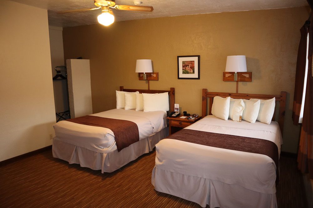
The town of Chinle is less than two miles from Canyon de Chelly, but it does not offer many accommodation options. I stayed at the Thunderbird Lodge, the only lodging inside the park. The charming lodge is Navajo owned and operated, and offers comfortable rooms, a cafeteria, a souvenir shop that also doubles as a small convenience store, and a tour desk.
For camping options, the Cottonwood Campground is the closest to the visitor center, while the Spider Rock Campground is a bit further along the south rim scenic drive.
Canyon de Chelly is part of the Navajo Nation, which observes Daylight Savings Time, unlike the State of Arizona. Therefore, there might be a time difference, so keep this in mind when planning your trip and making tour reservations.
Getting Around
There’s no public transportation in Canyon de Chelly, so you’ll need a car to drive the lengths of the north and south rim drives. Private vehicles are not allowed inside the canyon. Instead, join a guided tour of the canyon floor with a Navajo guide on 4WD, horseback, or hiking.
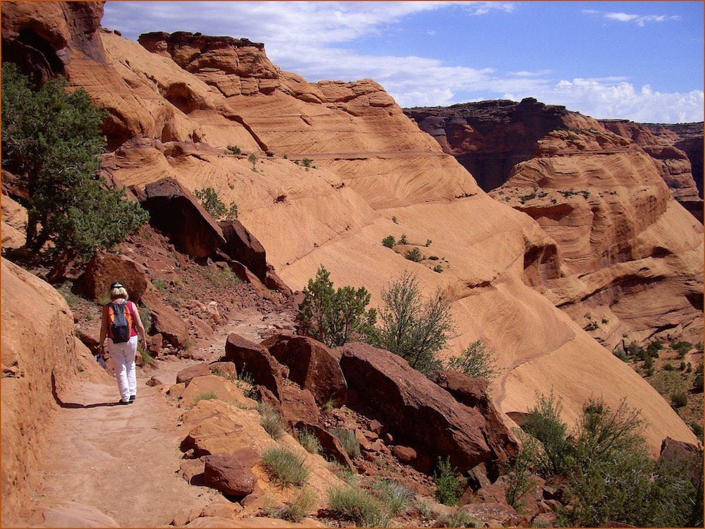
Hiking in Canyon de Chelly
Several hikes in Canyon de Chelly head to sections close to or on the canyon floor. The most famous hike is the White House Ruin Trail which can be done without a guide (check at the visitor center for any policy changes). Other hikes should be done with a Navajo guide. These include the Hanging Ladder to the Mummy Cave Trail, Baby Trail, and the Crack Trail.
(1) Get in touch with Footpath Journeys or Canyon de Chelly Tours for guided hiking excursions. (2) Guided hikes usually take between 3-6 hours. (3) Inquire at the visitor center if it’s possible to join a ranger-led hike.
What to Pack for Canyon de Chelly
Here are a few items worth considering when planning a trip to Canyon de Chelly. This is not an exhaustive list.
- Get your copy of the Lonely Planet guide to Southwest USA for information about Canyon de Chelly and other parts of your road trip.
- Water: bottles or a water pack
- Sun protection: hat, sunscreen, sunglasses
- Clothing: lightweight and sweat-repelling layers but also multiple warm layers for cool mornings.
- Extra warm clothing if visiting outside the summer months, including gloves, a warm hat, and a scarf.
- Dry weather: lip balm and tissues
- Light rain jacket in case of showers or a warm winter jacket.
- Safety: first-aid kit, walking poles (optional), sturdy hiking shoes, thick socks
- USB charger to charge your phone in the car
- Dress in layers
Canyon de Chelly Itinerary
The next section of this travel guide suggests an itinerary for spending up to 2 days in Canyon de Chelly.
Day 1: Canyon Floor Tour
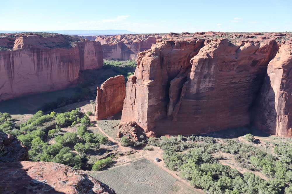
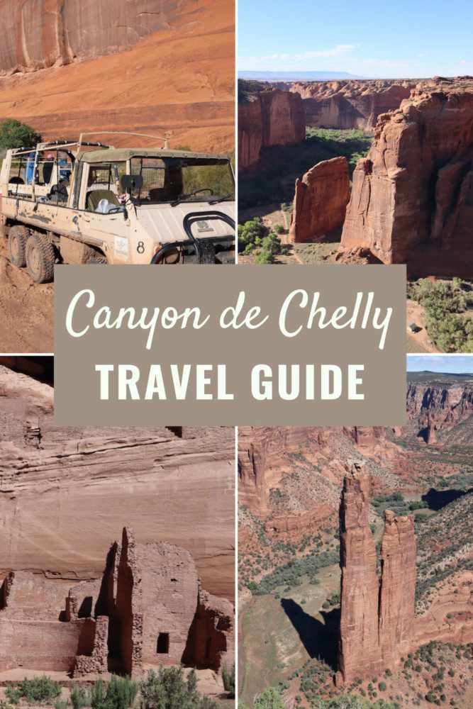
You certainly can do a rapid visit of Canyon de Chelly by driving the north and south rim drives (see day two itinerary). However, exploring the canyon floor with a Navajo guide is an experience you’ll never forget. Local operators offer half-day and full-day tours. The full-day tours run the entire length of the canyon and visit Spider Rock, while the half-day tours reach slightly beyond the White House Ruin before turning around.
(1) If you prefer the half-day canyon tour, book the afternoon tour if possible for optimal lighting conditions. However, morning or sunset tours might be preferable in the summer months because of the extreme heat. (2) It’s also possible to explore Canyon de Chelly on horseback. Check out Justin’s Horse Rental for more information.
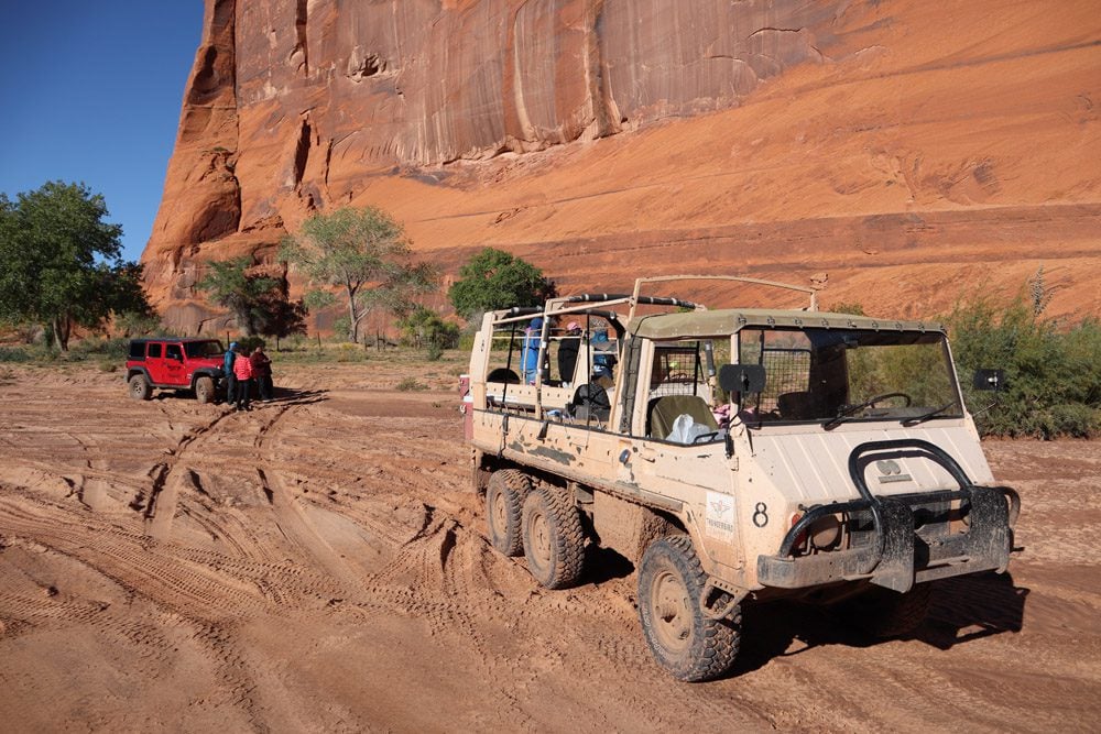
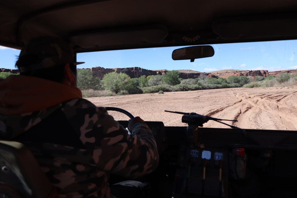
I booked my Canyon de Chelly tour via the Thunderbird Lodge. During my visit, full-day tours were unavailable, so I opted for a morning half-day tour as it was the only available option. We cruised the canyon floor on the Austrian-built Pinzgauer army troop carrier. This behemoth eats sand for breakfast and has no problems navigating the sandy canyon floor. Our Navajo guide was Elton, a knowledgable young man who isn’t shy about sharing the ins and outs of modern Navajo life.
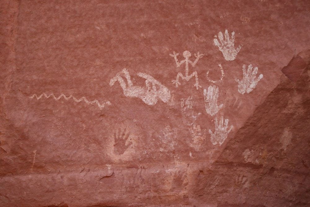
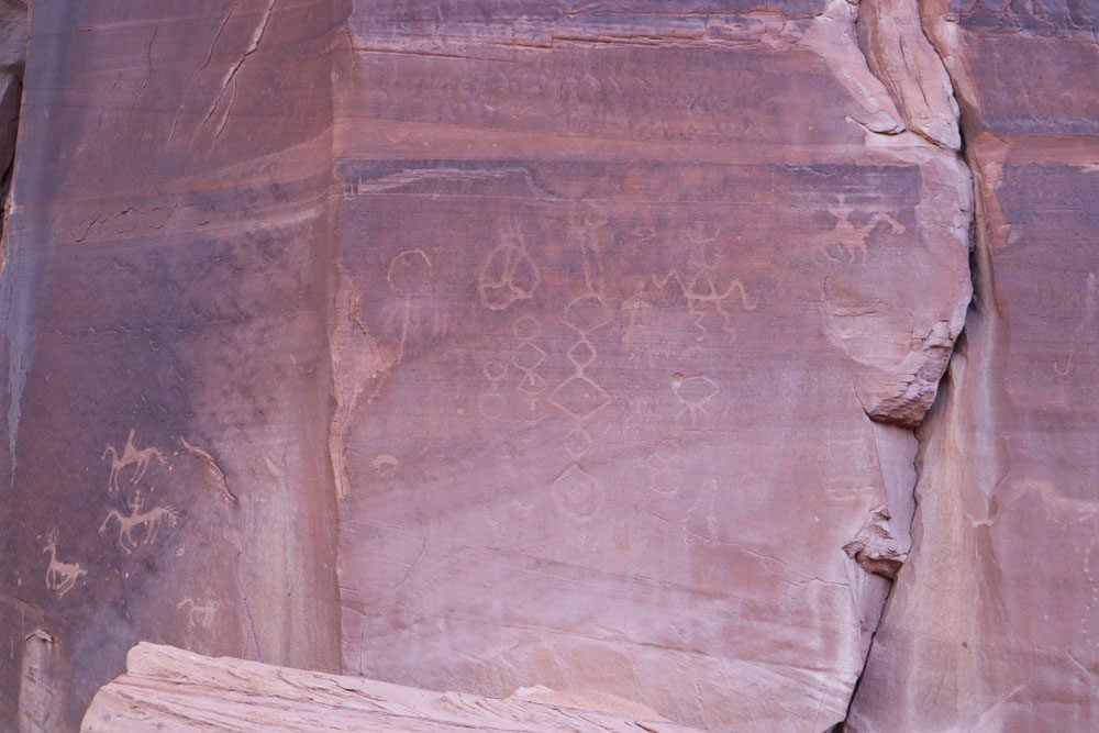
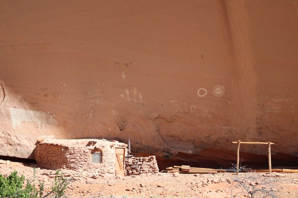
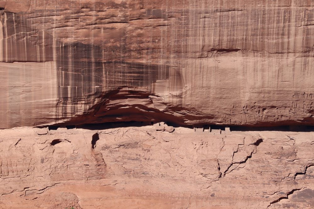
Our canyon tour started with a stop at rock carvings and paintings depicting ancient Anasazi life and the more recent Navajo contact with Spanish explorers. Some of these paintings were done by a local artist using rock minerals and animal fat. Every single line in these paintings has a meaning. I was especially amazed to learn how the Navajo constructed wood scaffolding to reach their “palette” high above the canyon floor.
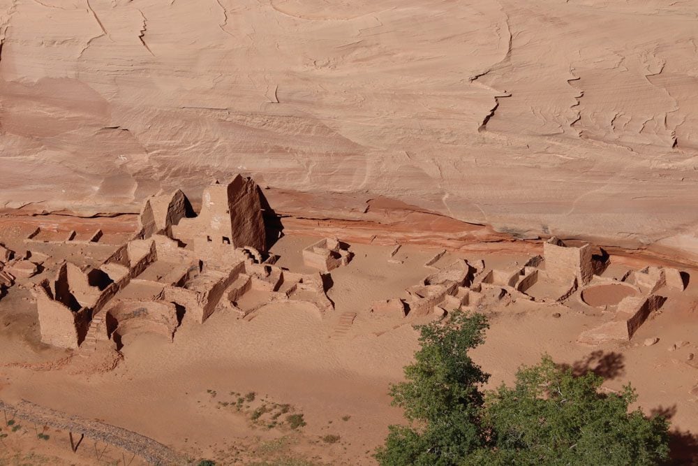
Our next stop was at the Antelope House Ruins, where we also made a brief stop at a local farm. The hot coffee and Navajo frybread were spot-on during this frosty morning. Antelope House is believed to have been constructed in the 7th century.
After Antelope House, we stopped at an additional rock painting site and paused several times for an explanation about what’s it like to live inside the canyon. We learned what canyon residents do for a living, the dangers of life at low elevation, and how ranchers feed their livestock when access to the canyon is blocked.
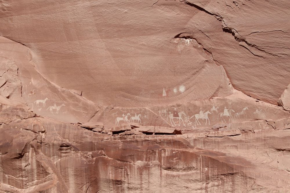
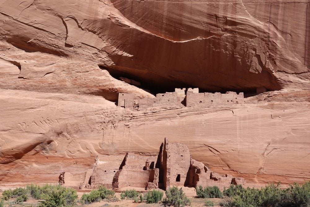
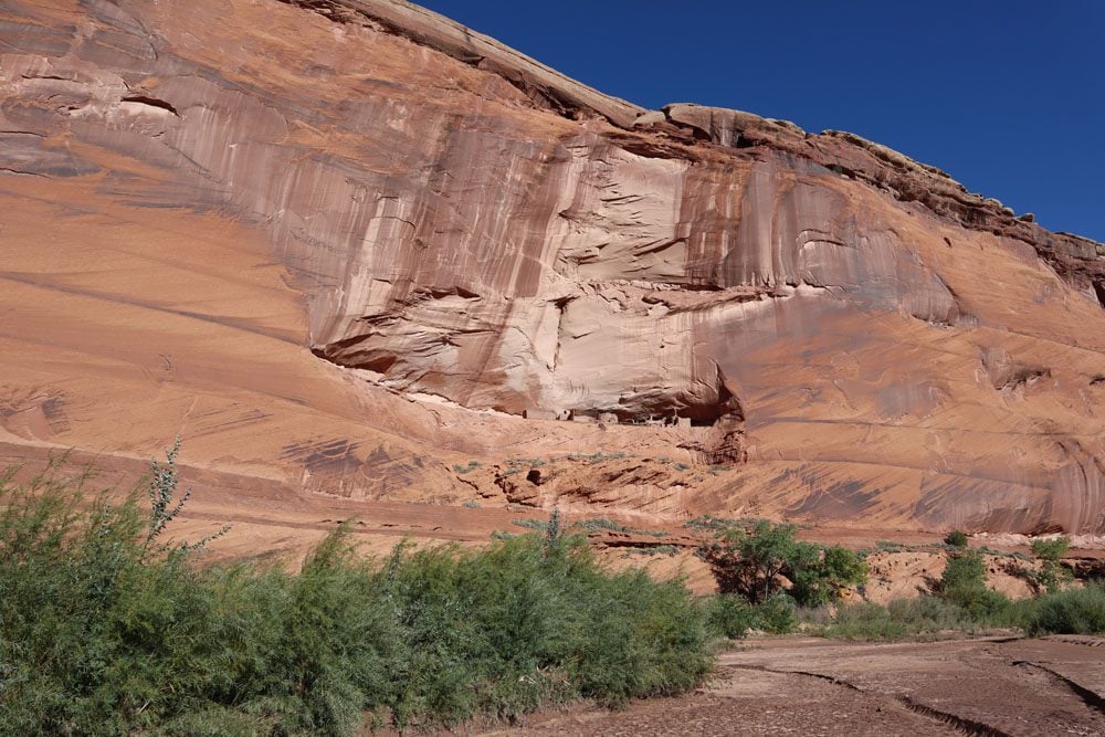
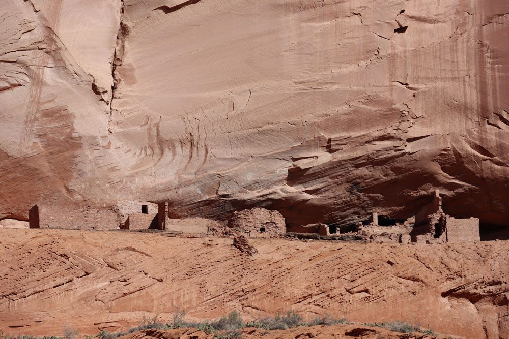
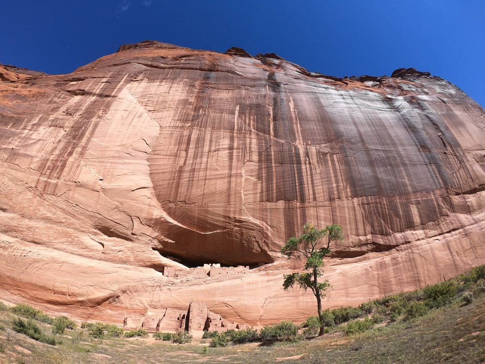
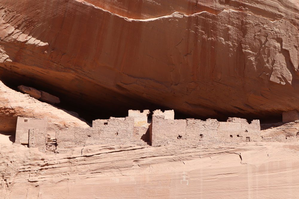
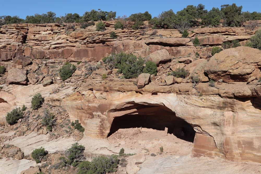
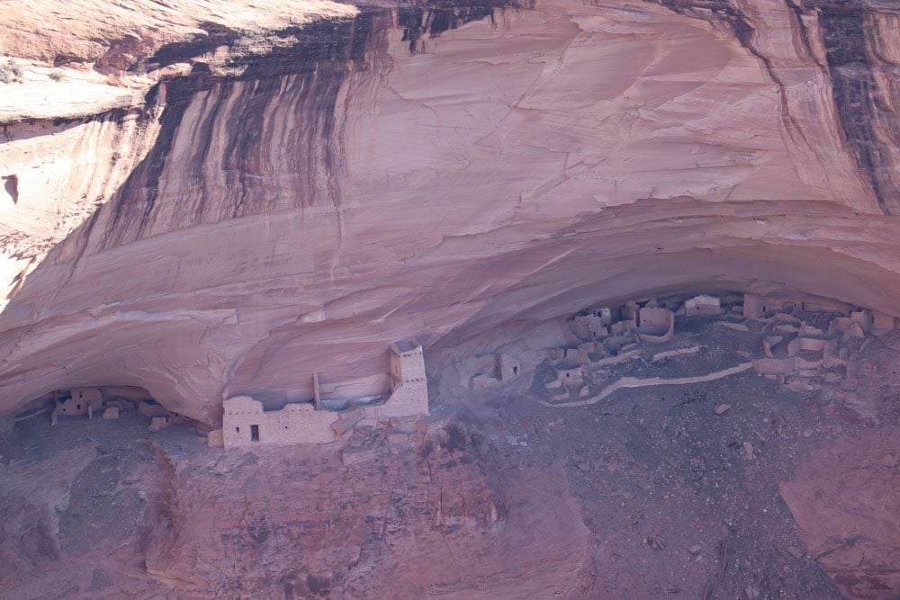
Our final stop was at the White House Ruins, undoubtedly the tour’s highlight. This picturesque “miniature city” was made with bright-colored plaster, hence the name. Seeing it from the canyon floor makes you wonder how the ancient tribes not only managed to build at this height but also how they survived everyday life, especially when it comes to getting fresh water.
If you did the half-day tour and still have some time left in the day, drive from the visitor center to Spider Rock (see “south rim scenic drive” below).
Day 2: Scenic Drives and Hiking
Use the second day in Canyon de Chelly or any time left after a half-day canyon tour to see the canyon from scenic viewpoints high above along the north and south rim drives.
Morning
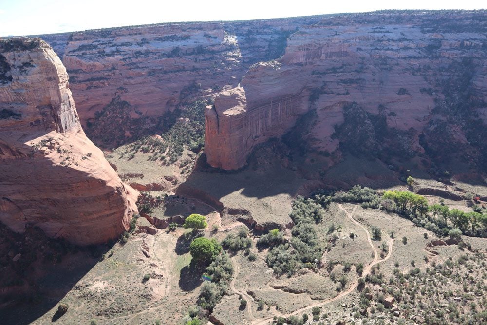
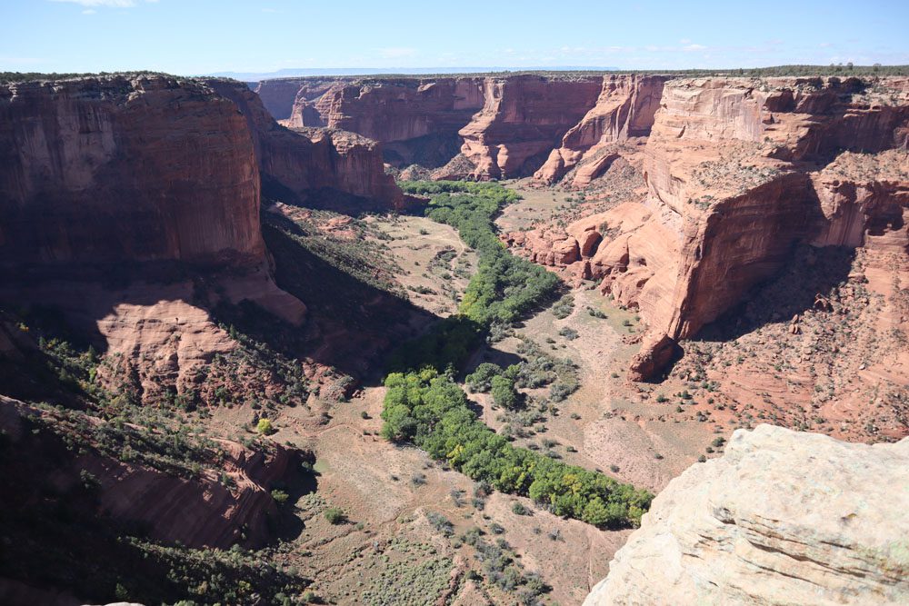
Spend the morning in Canyon de Chelly on the north rim scenic drive. Even though the south rim is more exciting, the north rim drive is better in the morning due to optimal lighting. The north rim drive extends about 13 miles from the visitor and follows the contours of Canyon del Muerto’s north rim.
I recommend driving to the furthest point and working your way back to the visitor center.
Massacre Cave Overlook
This is the furthest overlook on the north rim drive. Walk down from the parking area to the viewpoint for exceptional views of the canyon and the famous cave where Spanish forces killed over one hundred Navajo in 1805.
Mummy Cave Overlook
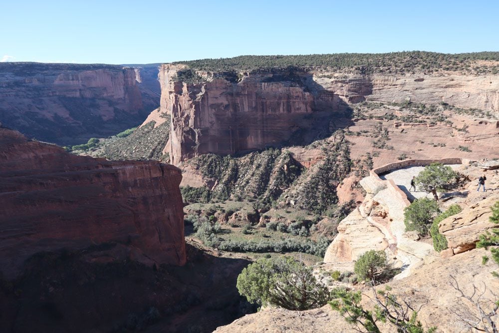
Slightly south of Massacre Cave Overlook, the views of Canyon del Muerto are even more impressive from Mummy Cave Overlook. From up here, see the canyon’s “choke point” and the beautiful pueblo ruins estimated to have been constructed in the 13th century.
Antelope House Overlook
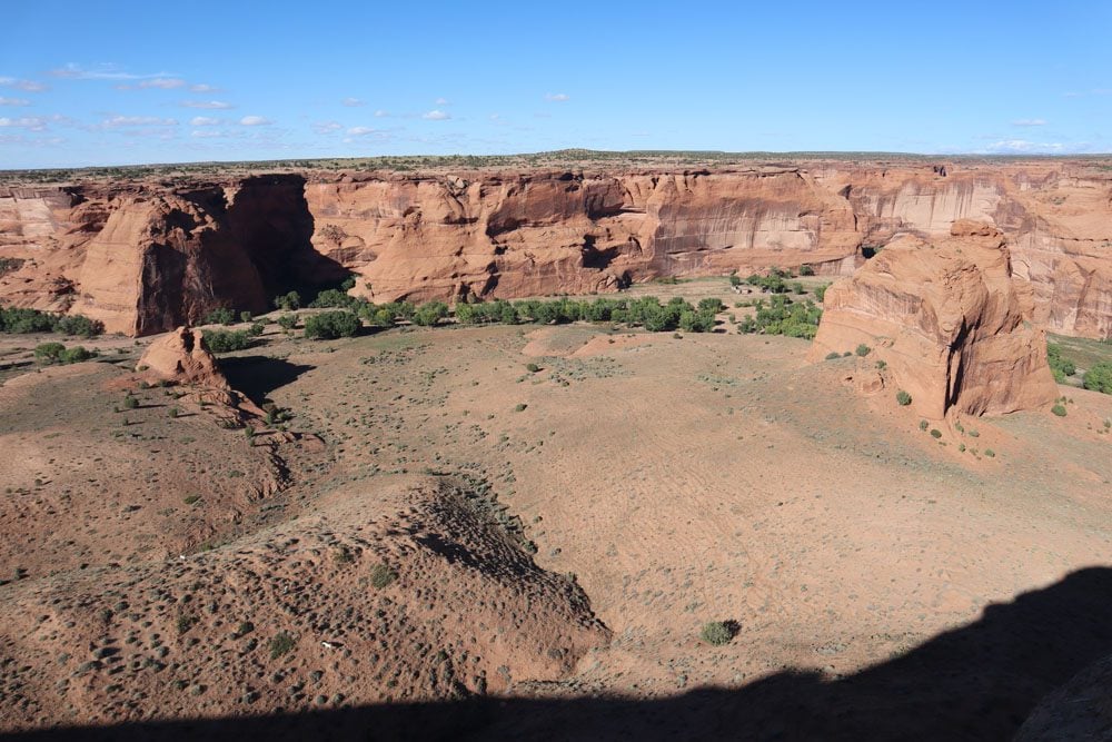
In my opinion, Antelope House Overlook is the most scenic stop on the north rim drive. This scenic overlook is strategically located above a beautiful bend in the canyon, home to cattle farms and small agricultural plots. The Antelope House ruins can also be seen from up here. This 7th-century site is also visited on canyon floor tours.
Afternoon
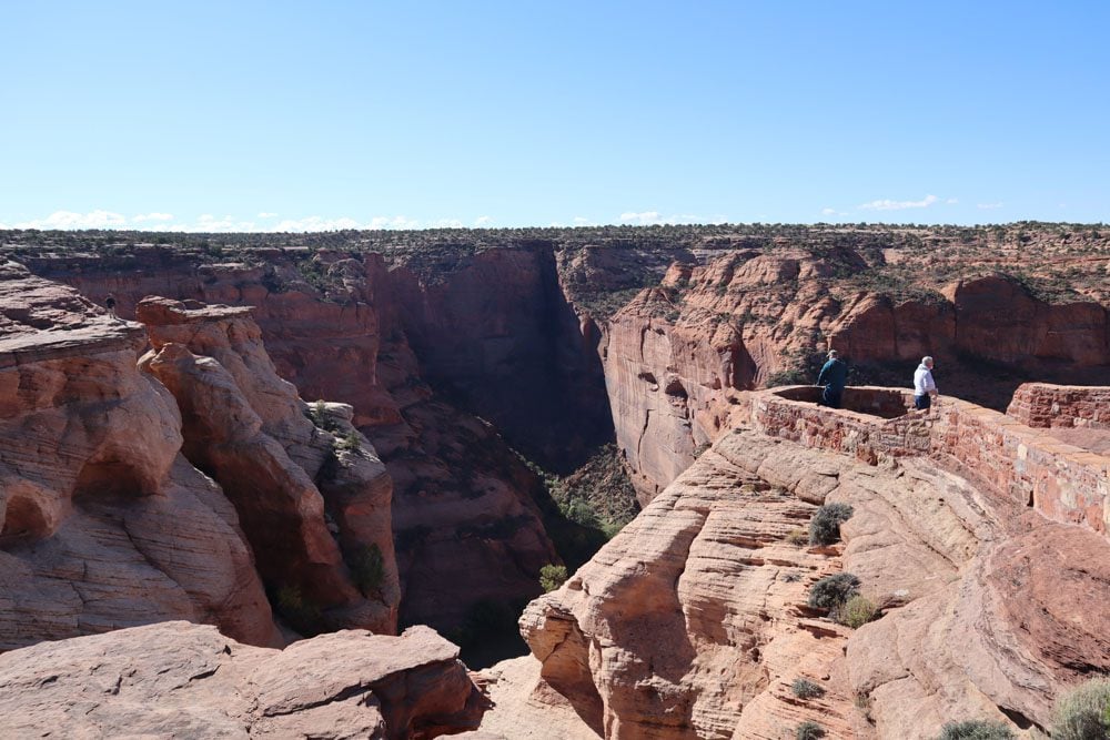
Spend the early afternoon in Canyon de Chelly on the 14-mile south rim scenic drive. Once again, start at the very end at Spider Rock and work your way back.
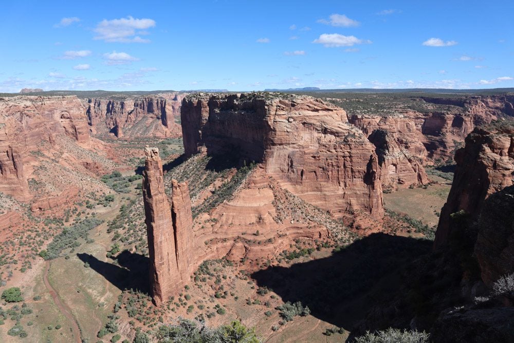
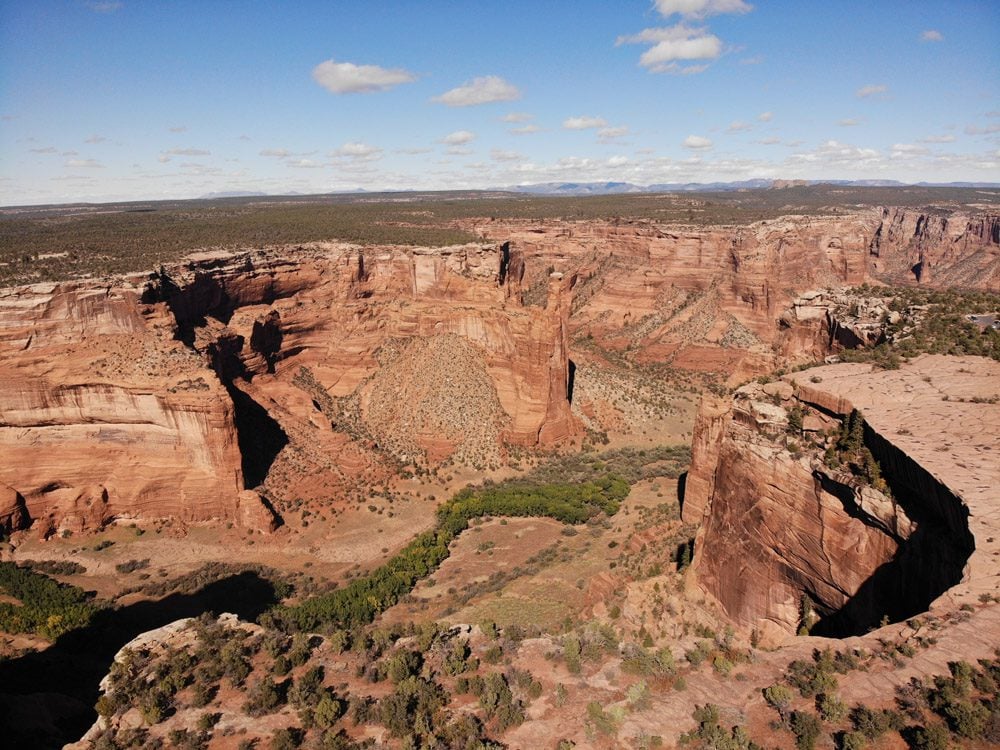
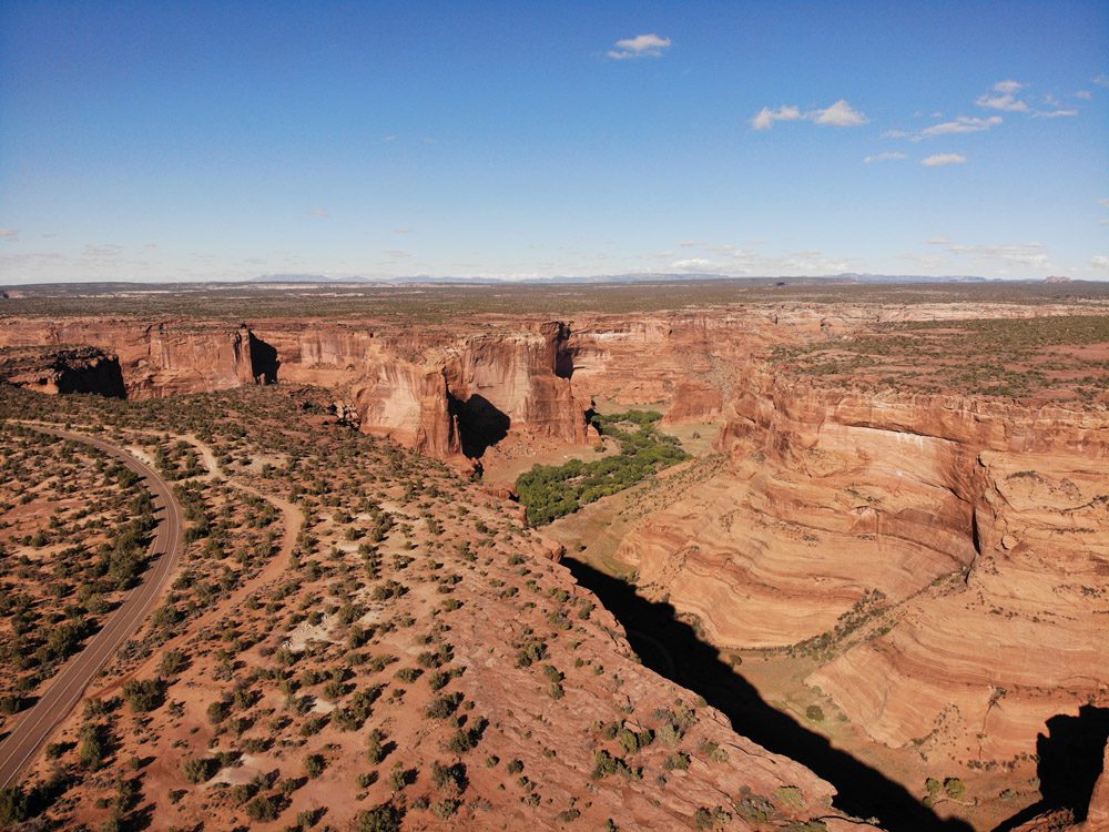
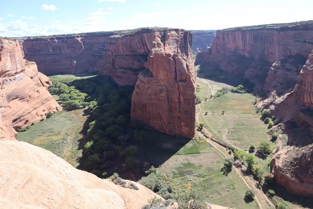
Spider Rock Overlook
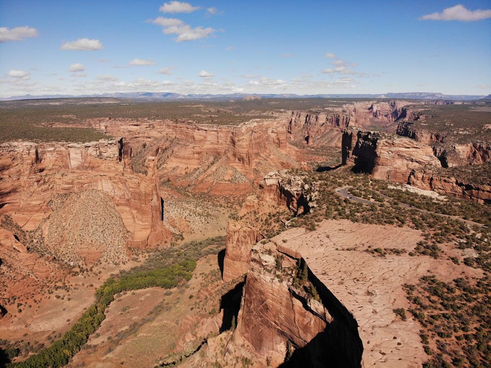
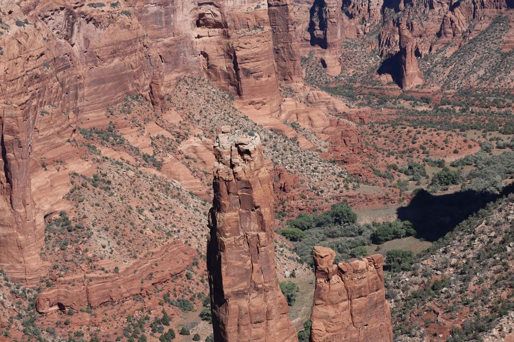
When you see pictures of Canyon de Chelly, they were likely taken at stunning Spider Rock Overlook. The highest of these sandstone spires rises over 700 feet from the canyon floor and marks the splitting point between Canyon de Chelly and the neighboring Monument and Bat Canyons. The Navajo believe that these monoliths are home to Spider Woman, who, on the one hand, taught them the art of weaving but, on the other hand, steals naughty children.
Face Rock Overlook
Stop at this viewpoint on your way back to the scenic drive and enjoy more panoramic views of the area.
Sliding House Overlook
The highlight of this viewpoint is the tiny cliff dwelling, which once again has you questioning how on Earth the ancient dwellers got up and down to get their daily chores done. Apart from the ruins, the canyon s magnificent from up here.
White House Overlook
This is one of the most popular spots in Canyon de Chelly, where you can see the famous White House Ruins and descend to the canyon floor on the self-guided White House Ruin Trail. Unfortunately, during my visit, the overlook and trail were closed, so inquire if they have since reopened.
Junction Overlook
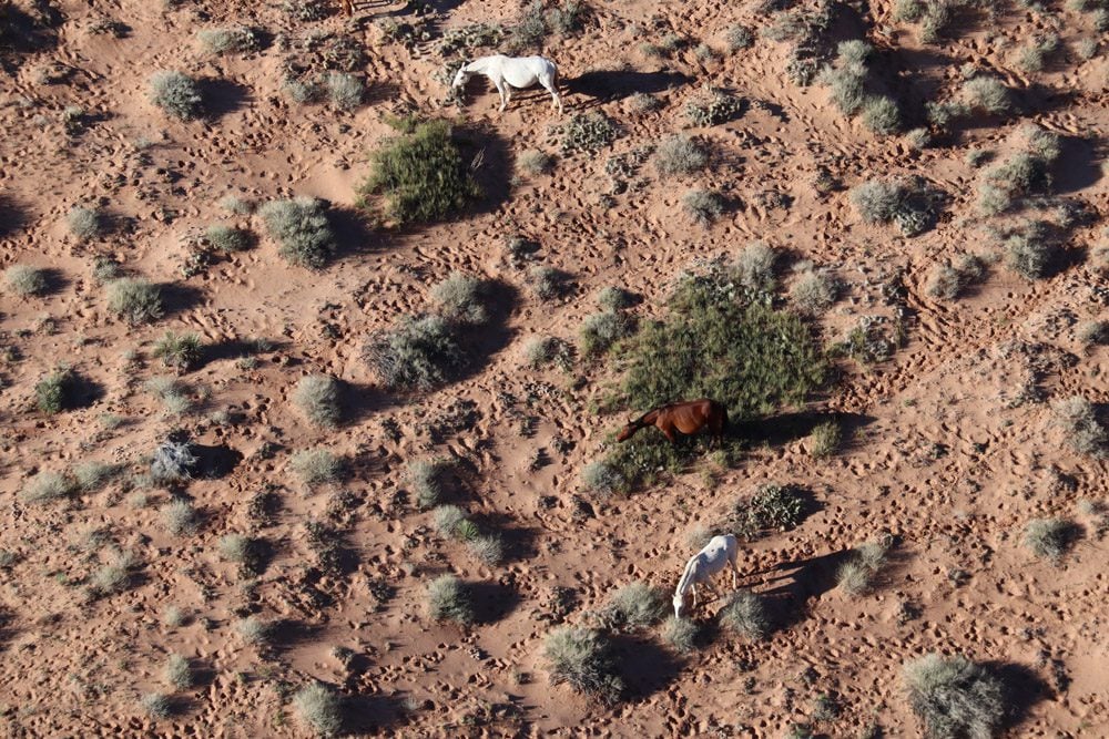
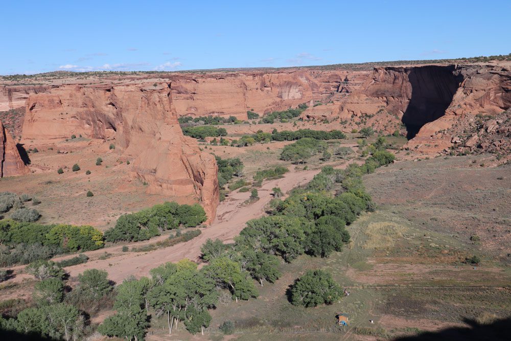
Junction Overlook offers eye-catching views of Canyon de Chelly and Canyon del Muerto’s meeting point. Try and spot horses grazing on the canyon floor below.
Tsegi Overlook
The last (or first) worthwhile stop on the south rim scenic drive. From up here, you can mostly see farms on the canyon floor and perhaps water flowing if it has recently rained.
White House Ruins Trail
If the trail is open, pause the south rim scenic drive at White House Overlook and pick up the White House Ruin Trail. This is currently the only trail in Canyon de Chelly that does not require a guide. The trail isn’t very long but will take a few hours to complete as what goes down must come up. The trail’s highlight is obviously the White House Ruins, but the terrain traveled en route is an experience on its own.
Highlights Beyond Canyon de Chelly
As mentioned in the travel tips section, Canyon de Chelly is usually a small part of a much broader road trip in the American Southwest. Here are a few worthwhile stops to combine with your visit to Canyon de Chelly.
Hubbell Trading Post
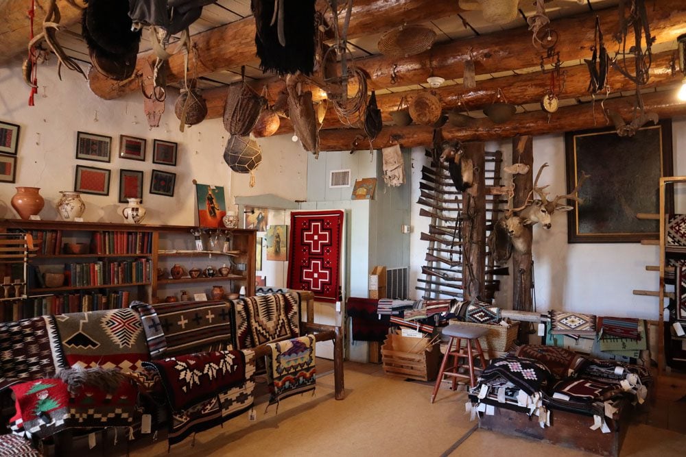
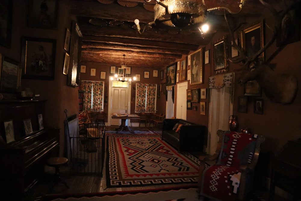
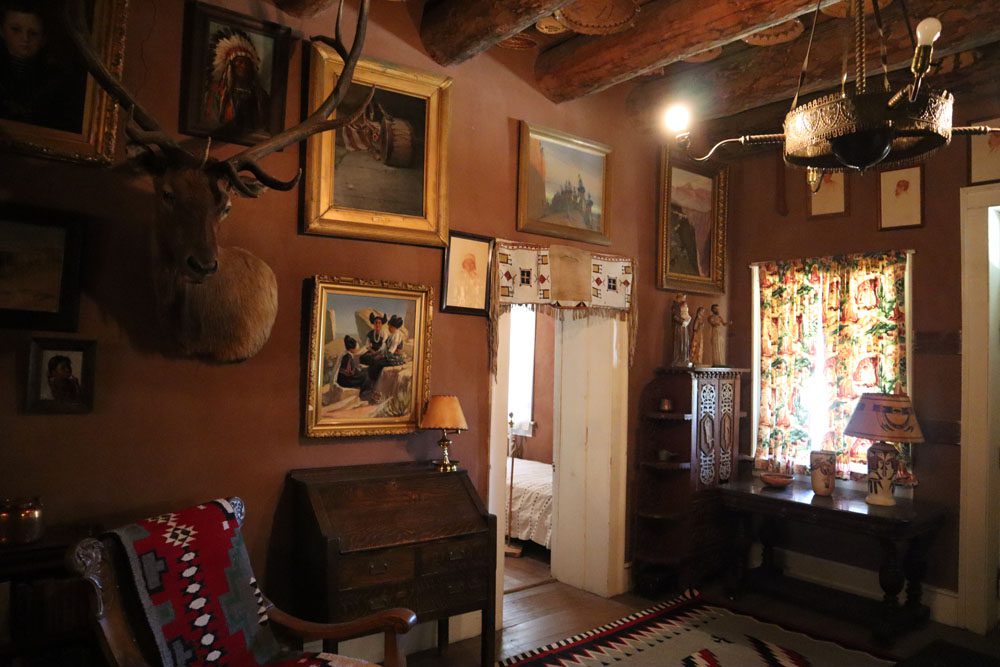
Located 40 miles south of Canyon de Chelly, history buffs will enjoy a visit to the Hubbell Trading Post National Historic Site in Ganado. This active trading post is the legacy of John Lorenzo Hubbell (related to astronomer Edwin Hubble), who purchased this land in 1878 and formed a lasting relationship with the local Navajo. It’s free to walk around and explore the various historical buildings, including the shop which sells exquisite Navajo crafts. However, be sure to stick around for the ranger-led tour of the Hubbell home. This magnificently decorated house was frequented by important guests of the time, including many artists.
Interstate 40
South of Canyon de Chelly and the Hubbell Trading Post, Intestate 40 heads west to Flagstaff. Along the way, stop at Petrified Forest National Park and explore one of the park’s sections. If you’re spending the night nearby, you’ll have time to explore both sections. Here’s a good rundown of the park’s star attractions.
Next, drive to Holbrook and step back in time to the 1950s. This small town feels like it hasn’t changed much since the Route 66 days. Spend the night or drop in for a quick visit to the Wigwam Motel and spend an hour in a time machine at the Holbrook Museum.
Further west, there’s not much happening in Winslow, but you could take your photo at the famous intersection mentioned in the classic Eagles hit Take it Easy. Surprisingly, Winslow is home to the exceptional La Posada hotel.
Hopi Mesas
The Hopi are a Native American tribe that primarily live in Northeastern Arizona. Highway 264 cuts through the heart of the large reservation and offers a chance to visit three impressive ancient Hopi villages set atop high mesas. They’re named First Mesa, Second Mesa, and Third Mesa. Below each ancient site lies a modern village. Guided tours are the only way to visit the mesa villages, the most impressive of which is Walpi (First Mesa).
Southern Utah Backcountry
The Moki Dugway and Muley Point are just some of the scenic highlights on a seemingly pointless detour. However, dedicate a day to this scenic drive if you want to experience “classic” Southern Utah sites without the national park crowds. One approach is from Highway 163 beyond Monument Valley and the famous frame from Forest Gump. Beyond Mexican Hat, Take Highway 61 or continue to the Valley of the Gods. At the junction with Highway 95, head west to Natural Bridges National Monument or east to House in Fire, Butler Wash Ruins, and back to civilization at the junction with Highway 191.
Navajo National Monument
On the way to Page, Navajo National Monument is home to some of the most impressive Ancestral Puebloan cliff dwelling sites in the region, the most famous of which is Betatakin.
The Four Corners
More of an answer to a trivia question rather than a scenic highlight, the Four Corners National Monument is the meeting point of four state borders: New Mexico, Colorado, Utah, and Arizona.
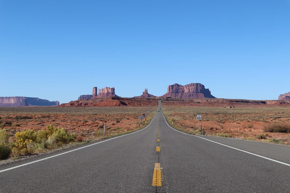
Monument Valley
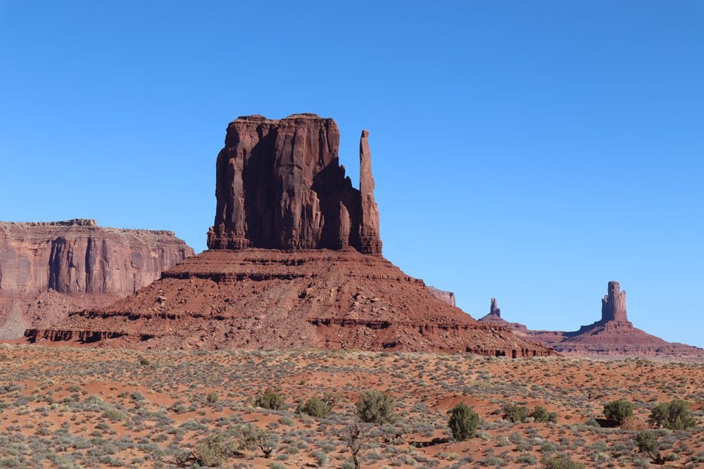
See iconic Wild West scenery in Monument Valley. Spend the night at the View Hotel, and don’t forget to catch the sunset, stargaze at night, and rise early for sunrise. Then head to the famous spot where a scene from Forest Gump was filmed. Surely you recognize this spot from popular culture. Wrap up the visit with a Navajo-led or DIY tour of the scenic drive, and if there’s any time left, hike the Wildcat Trail.
Mesa Verde
Visit Mesa Verde National Park if you were impressed by the cliff dwellings at Canyon de Chelly. Mesa Verde’s cliff dwellings are some of the most impressive in the Southwest.
What’s Next
With this Canyon de Chelly travel and guide and itinerary, you’re now ready to visit one of Arizona’s most prized gems and even make a few interesting stops on the way or after your visit. Before hitting the road, check out additional Arizona and Southwest USA travel guides.
Pin These Images To Your Favorite Boards!