Pacific Coast Highway Itinerary San Francisco To Los Angeles - post cover

Pacific Coast Highway Itinerary: San Francisco To Los Angeles

Pacific Coast Highway Itinerary: San Francisco To Los Angeles

Published on April 3rd, 2022

The Pacific Coast Highway is one of America’s ultimate road trips, stretching for over 600 miles along the coast of California. Along the way, road trippers are treated to sensational views, natural gems, and charming towns where they can spend the night or stretch their legs. In this travel guide, we’ll explore a Pacific Coast Highway itinerary for driving from San Francisco to Los Angeles or vice versa.

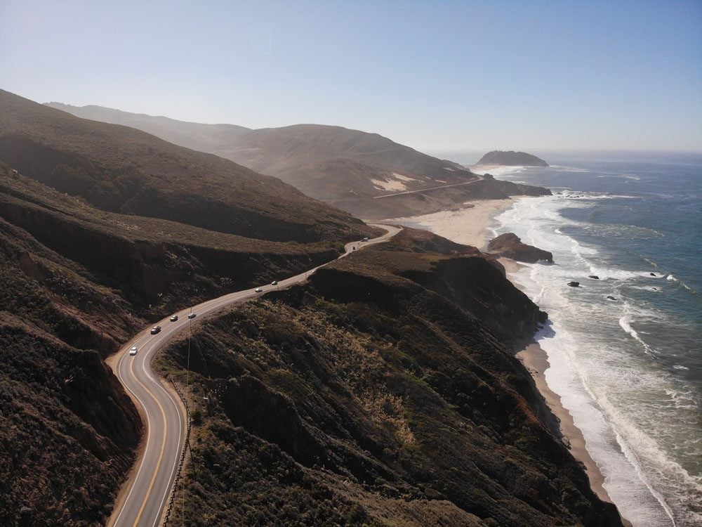
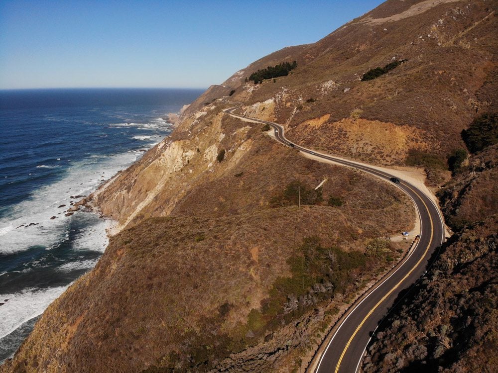
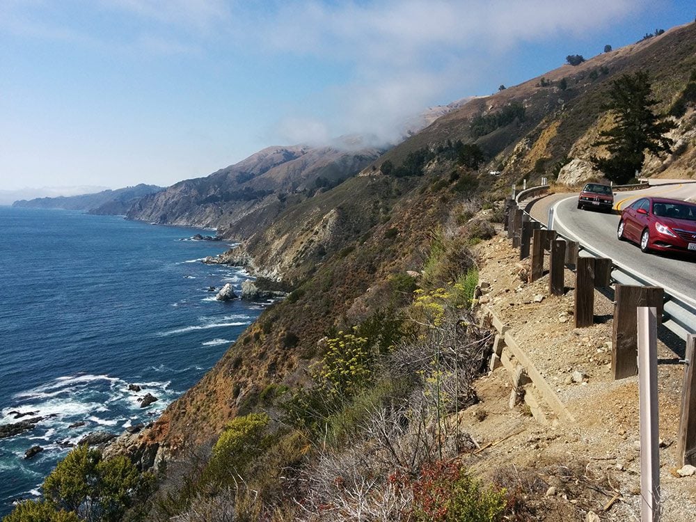
I’ve cruised up and down California State Route 1, better known as Highway 1 or the Pacific Coast Highway (PCH) on several occasions, most recently on a five-week road trip in America’s southwest. I’ve always been amazed at this engineering marvel and how the road manages to traverse such an imposing coastal terrain at times. Combined with the California vibe of perpetual vacation, there’s an overpowering sense of freedom on the PCH, without a doubt one of the world’s best scenic drives.

Highway-1-Pacific-Coast-Highway-California-road-trip
Before we begin

This Pacific Coast Highway itinerary covers the distance from San Francisco to Los Angeles. Of course, you can drive in either direction but this Highway 1 itinerary will follow the route from the City by the Bay to the City of Angels. You can continue cruising north past San Francisco and south from Los Angeles toward San Diego.

Why Visit the Pacific Coast Highway?

McWay Falls Big Sur California Pacific Coast Highway
Big Sur

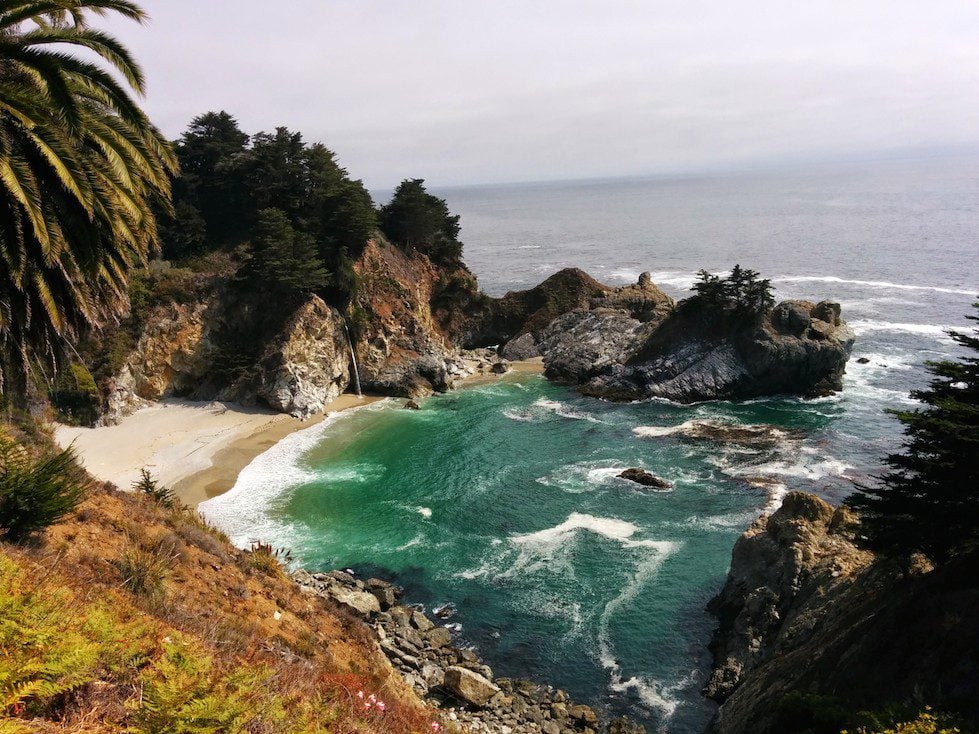
The PCH’s crown jewel poses a challenge for drivers as they must carefully weave around sea cliffs while attempting to enjoy the sensational views. Luckily, there are plenty of road side viewpoints and hikes to interesting sites.

Santa Barbara Beach by www.traveljunction.com
Charming Towns

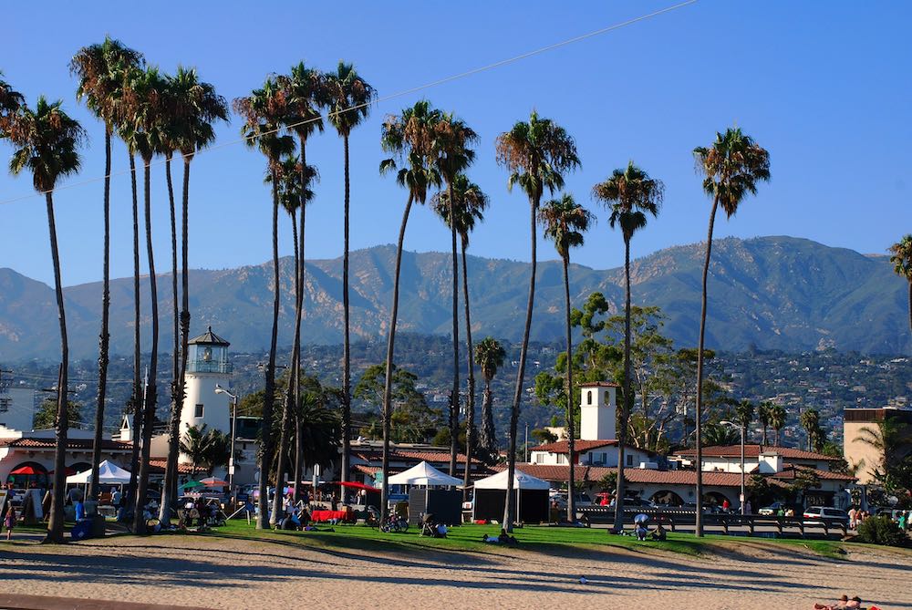
The PCH is dotted with charming towns to spice things up with. Notable mentions include Pacifica and Santa Cruz in the north, Carmel and Pacific Grove in “the middle”, and Santa Barbara, and Morro Bay in the south.

winding-road-on-pacific-coast-highway
Ultimate Road Trip

On the PCH, freedom is often the word used to describe one’s feeling. Perhaps due to the road’s depiction in popular culture or perhaps it’s the scenery. Whatever the case may be, the PCH brings out the “young self” in every road tripper.

What’s Included in this Pacific Coast Highway Itinerary?

Several sections make up this San Francisco to Los Angeles Pacific Coast Highway itinerary

quote-blue
Pro-Tip-Lightbulb-Icon
Pro Tip

This itinerary spans a little over 450 miles (725 km) and 9 hours of driving from San Francisco to Los Angeles. While some short sections deviate from the PCH, most of the driving is along the coast. You can shorten this plan to 3 days by skipping some of the mentioned sites and spending one night in Carmel and one night in or around Morro Bay.

Additional Pacific Coast Highway Resources

Before planning your road trip, be sure to go through the essential PCH travel tips guide. For a quick read of the top things to see and do along the Pacific Coast Highway, check out the top 10 list. If you’re looking for a shorter road trip from San Francisco to Big Sur and back, check out this travel guide.

Pacific Coast Highway Travel Tips - thumbnail
Top Things to do on Pacific Coast Highway - thumbnail
Quick Finds
Where to overnight on this PCH road trip?

This itinerary calls for three overnights, though you can shorten the trip to just two nights and three days (see pro tip above). I recommend spending the first night in Carmel or nearby Pacific Grove, the second night in Big Sur, and the final night in Santa Barbara. Since there are not many accommodation options in Big Sur, I highly advise booking as early as possible.

cars driving on the pacific coast highway

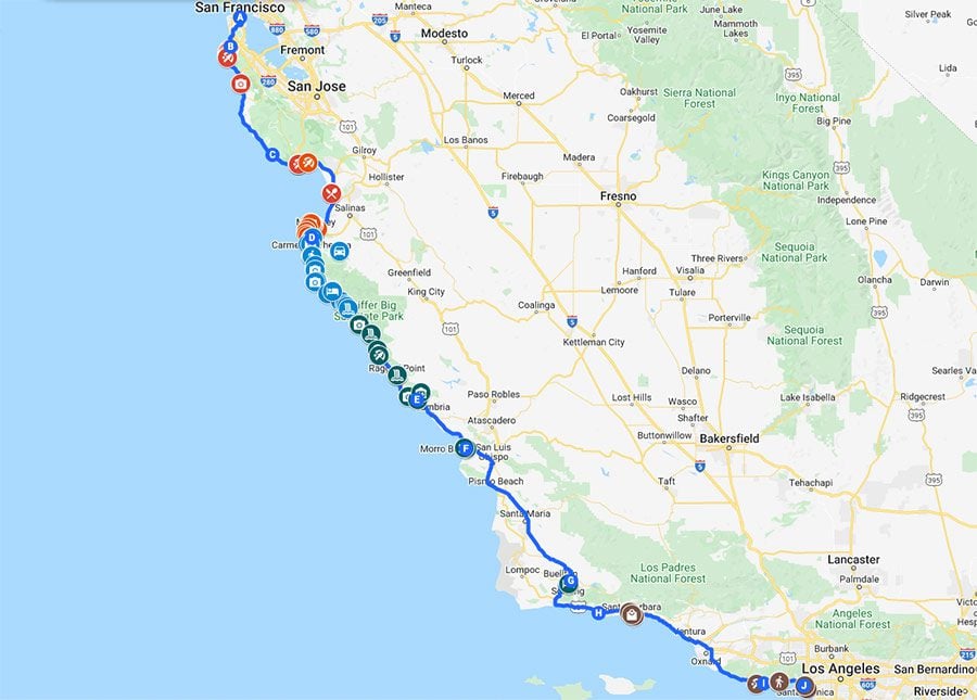
San Francisco to Los Angeles Pacific Coast Highway Map

This map contains all the places mentioned in this Pacific Coast Highway itinerary. Simply click on the image to open it in Google Maps

Pacific Coast Highway Itinerary San Francisco To Los Angeles map

Day 1: San Francisco to Carmel

The first leg of this Pacific Coast Highway itinerary from San Francisco to Los Angeles takes us along the coast to the southern tip of Monterey Bay where we’ll spend the night. It’s important to get an early start to not feel rushed or have to skip some of the sites along the way.

Pacifica to Half Moon Bay

Pacifica is a charming beach town just 15 miles south of San Francisco. It is beyond Pacifica that you really leave the big city behind and begin to experience the thrills of the Pacific Coast Highway. Check out Pacifica State Beach and see if any surfers are catching waves or continue further down the road to hike or all part of the Pedro Point Headlands Trail or the Devil’s Slide Trail if there’s enough time and no heavy fog.

Pacifica California - pacific coast highway

Further south, see if you can spot any whales at Gray Whale Cove Beach and if you feel the urge to walk on sand, take the steep marked trail down to the beach. Across the road, the Gray Whale Cove Trail will take you to higher grounds for more panoramic views of the area.

Four miles south of Gray Whale Cove Beach, check out the long stretch of golden sand at ​​Martini Creek from the side of the road, or head down for a stroll if you have yet to stretch your legs. 

At Half Moon Bay, there are no prime reasons to stop unless you need to take a break, buy something for the rest of the day or fill up gas. However, if you’re driving between February and March, see if the wild mustard field is open and see what it’s like when thousands of yellow flowers bloom at the same time.

Santa Cruz

Santa Cruz can be a fun stop if you’re looking for a good time or traveling with children. If that’s the case, skip the stops mentioned in the previous section and head straight to Santa Cruz along Highway 1 so you still get to enjoy the coastal views. 

Santa Cruz sits at the northern tip of Monterey Bay, beginning as a modest Spanish mission in 1791. These days, Santa Cruz is quite a happening town, primarily thanks to the presence of thousands of university students and its attraction-filled waterfront. That said, if you drive around, you will find a few “suburbia-style” neighborhoods with fine ocean views and palm trees. 

Park your car close to the waterfront and explore Santa Cruz’s main highlights. Start at the municipal wharf, which extends far into the bay and from where pretty views of the beach and waterfront can be enjoyed. This is also a worthwhile stop if you’re just looking for a quick visit. The municipal wharf is home to a few seafood restaurants if you’re craving lunch. 

Santa Cruz municipal wharf pacific coast highway

Back on solid ground, take a left to Cowell Beach for a quieter experience, or continue to Santa Cruz Beach to see if any intense beach volleyball matches are taking place. The main attraction is the Beach Boardwalk, the oldest amusement park in California. Both adults and children will enjoy some of the rides, including the legendary Giant Dipper wooden rollercoaster. In the back, a large arcade with lots of tempting video games can keep the kids busy a while longer.

Santa Cruz Beach Boardwalk amusement park pacific coast highway
beach volleyball santa cruz pacific coast highway
quote-blue
Pro-Tip-Lightbulb-Icon
Pro Tip

If you’re looking for a quieter experience, head to nearby Capitola to explore on foot its downtown area and Capitola Beach.

Moss Landing

As you head south along Monterey Bay, the Pacific Coast Highway swings inland. At Moss Landing, Highway 1 briefly nears the coastline once again. If you opted out of stopping at Santa Cruz or Capitola, stretch your legs at Moss Landing and go for lunch at Phil’s Fish Market & Eatery, or Haute Enchilada for Mexican specials. Along with Monterey, Moss Landing is a prime departure point for whale-watching tours. Check out Sanctuary Cruises, one of the more respected outfits for such excursions.

quote-blue
Pro-Tip-Lightbulb-Icon
Pro Tip

Orca whales (a.k.a killer whales) and dolphins can be spotted throughout the year. Gray whale season is between December and March, and humpback and blue whales can be seen between April and November.

The area further inland to Moss Landing is known as “America’s Salad Bowl”. Towns such as Salinas focus on agriculture and you’ll notice this especially if you take a slight detour to see the area that served as the backdrop to John Steinbeck’s novel Of Mice and Men. Stop at roadside stalls and pick up some local produce for picnic lunches on the following days.

Monterey

The city of Monterey was a major fishing town back in the day. While there’s still commercial fishing operating from Monterey, the city nowadays caters more to tourists than to the fishing industry. Unless you’re doing well on time or if the weather is bad, or if you’re traveling with children, don’t feel too obliged to stop in Monterey. 

If you do decide to stop and explore Monterey, Cannery Row and the Old Fisherman’s Wharf are the prime attractions on foot, while the world-class Monterey Bay Aquarium will certainly impress the kids. If you want to spend more time in Monterey, head to Municipal Wharf #2 for the vibe and to Monterey State Historic Park to learn about the area’s origins.

fishermans wharf monterey california
cannery row monterey california

Pacific Grove

If Monterey was an optional stop, Pacific Grove is hard to resist. This small town has some seriously nice ocean views and charming Victorian-style homes. If you feel like making a proper stop, park the car in the downtown area and head to Pavel’s Backerei to buy some baked goods or grab a table at the Red House Cafe

red house cafe pacific grove california

Walk to Pacific Grove’s most famous spot at Lover’s Point to enjoy the romantic views and, if it’s between October and February, walk to the Monarch Grove Sanctuary to see thousands of monarch butterflies at work. Back in the car, drive along Ocean View Boulevard which turns into Sunset Drive past Beach Point and the Kissing Rock. History buffs can also stop and visit the Point Pinos Lighthouse, the oldest continually operating lighthouse on the West Coast. 

quote-blue
Pro-Tip-Lightbulb-Icon
Pro Tip

Together with Carmel, Pacific Grove is an ideal location for spending the night on the first leg of this San Francisco to L.A. Pacific Coast Highway itinerary. Just be sure to book in advance as its top bed and breakfasts sell out quickly.

17-Mile Drive

As the name suggests, this scenic road is 17 miles long, connecting Pacific Grove with Carmel. It’s a private road that runs inside the gated community of Pebble Beach and its legendary golf course. Visitors have been flocking to this area, known as the Del Monte Forest, since 1881. There are several ways to enter 17-Mile Drive but we’ll enter from the Pacific Grove gate and exit in Carmel. When you enter and pay the fee, you’ll get a detailed map of the area. 

The drive itself is very slow-going, especially in the non-coastal sections which pass through forested residential areas and clubhouses. If you’re pressed for time, simply stick to the coastline as that’s where all the top highlights are. When driving along the coast on 17-Mile Drive from Pacific Grove, it’s worth stopping at Spanish Bay where Spanish explorers camped back in 1769, Bird Rock with its wooden boardwalk over the sand, Seal Rock and its usual sightings of birds and seals, the Lone Cypress from where you’ll get picturesque views of Carmel Bay, and Pescadero Point

seal rock - 17 mile drive - pacific coast highway
bird rock - 17 mile drive - pacific coast highway
spanish bay - 17 mile drive - pacific coast highway
lone cypress - 17-Mile Drive
seagull on 17-Mile Drive

Carmel

We’ll end the first day in this Pacific Coast Highway itinerary from San Francisco to Los Angeles at Carmel-by-the-Sea. More commonly known as Carmel, this is the residential jewel of the Monterey Peninsula, a highly affluent community that goes to lengths to preserve order and tidiness in their village. Just look at some of the municipal laws that were petitioned or passed in recent years such as banning neon signs or requiring a permit to wear high heels over two inches. In addition, many residential homes in Carmel are not street numbered. Instead, they are found by describing their physical location relative to other homes, intersections, etc.

Apart from the high average net worth of its community, Carmel owes its modern-day claim to fame to the countless art galleries dotting its side streets, an abundance of fancy cars lining its avenues, and one famous former mayor, Mr. Clint Eastwood. It also has a beautiful beach, a historic Spanish Mission, and a lovely state park practically in its backyard. 

quote-blue
Pro-Tip-Lightbulb-Icon
Pro Tip

Together with Pacific Grove, Carmel is an ideal location for spending a night on the first leg of this San Francisco to L.A. Pacific Coast Highway itinerary. Just be sure to book in advance as its top bed and breakfasts sell out quickly.

Carmel Mission

By now it’s late in the afternoon so drive to the Carmel Mission before it closes (check opening days and times). Established in 1771 by Spanish missionary Junipero Serra, the tranquil mission has a lot of history, having changed hands between Christian missionaries, Mexican authorities, and finally the Americans. Explore the mission’s basilica and the gardens to get a feeling of what it was like here, centuries ago. There’s also a modest museum inside showcasing life in the old days.

Carmel Mission - carmel by the sea - pacific coast highway
carmel mission - basilica interior - pacific coast highway
cross in courtyard carmel mission - pacific coast highway
carmel mission exterior courtyard - pacific coast highway

On the way back to the village center, check out some of Carmel’s charming homes, especially along Torres Street which weaves its way around trees. Between 5th and 6th Avenue, check out the famous Hansel and Gretel House.

Carmel Center

Back in the village center, go for a stroll down Ocean Avenue towards Carmel Beach but take the long route by exploring the avenues that cross this major artery. You’ll notice a recurring theme of fine dining restaurants, boutiques, fancy sports cars, and art galleries. Some side streets also hide narrow passages that carve deeper into the neat grid. On Dolores Street between 5th and 6th Avenues, the “secret garden” is a worthwhile passage to explore, leading to a Tibetan shop with its relaxing sounds and incense.

fancy cars in carmel - pacific coast highway
restaurant in carmel california pacific coast highway
restaurant in carmel by the sea - pacific coast highway

Carmel is well known for its high concentration of art galleries and part of the fun of exploring the downtown area is seeing the beautiful art on display. For some visitors, window shopping may be enough, but if you’re extra curious, feel free to step inside and check out the works from up close. The “gallery tour” is worth a second look at night when Carmel’s art galleries are beautifully lit.

art gallery at night - carmel by the sea - pacific coast highway

Carmel Beach

We’ll end the day at beautiful Carmel Beach, the perfect spot for watching the sunset. During the day, you might spot dolphins swimming close to the shore, and definitely see the Pebble Beach Golf Links when looking north.

carmel beach - pacific coast highway
sunset in carmel by the sea - pacific coast highway

Dinner 

If you’re overnighting in Carmel, advanced dinner reservations are highly recommended. Carmel is mostly about fine dining but there are a few simple eateries to go along with less pretentious restaurants such as Cantinetta Luca. If you stayed in Pacific Grove, head to the Red House Cafe. Located in a red Victorian-style house dating back to 1895, this restaurant serves American food with a European touch. For seafood, check out the Passionfish Restaurant.

Day 2: Big Sur

The mountainous section between Carmel and San Simeon is known as Big Sur and that’s the focus of day two of this Pacific Coast Highway itinerary from San Francisco to Los Angeles. In certain sections of Big Sur, the highway is tightly wedged between the Santa Lucia Mountains and the Pacific Ocean. There isn’t much room for error and that’s part of the allure. 

quote-blue
Pro-Tip-Lightbulb-Icon
Pro Tips

(1) Drive with extra care in Big Sur and remember that a scenic lookout is always nearby so there’s no reason to take your eyes off the road. Plan for extra driving times than what you’re used to. (2) Gas stations are few and far in between in Big Sur, not to mention very expensive. Be sure to fill up the tank before heading out.

winding-road-on-pacific-coast-highway

Morning in Carmel 

If you didn’t get a chance to check out Carmel Beach yesterday, go for a quick stroll before continuing the push south to Big Sur. There will also be multiple opportunities on this day for a picnic lunch, so stop at Carmel Bakery to pick up baked goods along with other culinary favorites from nearby shops.

Point Lobos Natural Reserve

Just south of Carmel, Point Lobos State Natural Reserve is a worthwhile stop en route to Big Sur. Because of its position on a small peninsula extending into the Pacific, Point Lobos offers fine southbound views toward Big Sur. The marine life in Point Lobos is extremely rich thanks to the high concentration of nutrients in the water. For a quick taste, the easy Sea Lion Point Trail leads to small coves and vistas from where you should be able to spot seals swimming in the water or catching some morning rays on one of the rocks further offshore (binoculars come in handy). If you’re lucky, you might even spot some gray whales. Another popular spot is Whaler’s Cove but parking there can be challenging. 

quote-blue
Pro-Tip-Lightbulb-Icon
Pro Tips

(1) If the morning fog is really heavy and it doesn’t yet make sense to hit the road, head inland to spend a couple of hours at Carmel Valley with its ranches and wineries. There’s a better chance of sunshine over here than along the coast. (2) Your entry ticket to Point Lobos should also be valid at Julia Pfeiffer Burns State Park if used on the same day.

Sea Lion Point - Point Lobos State Natural Reserve
sea lions at - Point Lobos State Natural Reserve

Soberanes Point

Part of Garrapata State Park, Soberanes Point is a worthwhile stop, even if just a quick one to enjoy the views. If you have the time, you can hike the three-mile round-trip Soberanes Point Trail or head further inland on the strenuous Soberanes Canyon Trail.

Notleys Landing Viewpoint

This is another recommended scenic lookout and it comes just before Bixby Bridge. It’s very tempting to cross the fence and head to the cliff’s edge from where you can clearly spot the bridge in the distance, but this is private land so enjoy the view from the side of the road.

Bixby Bridge

There’s a very good chance you’ve seen Bixby Bridge in popular culture or perhaps in car commercials. It’s one of the top highlights along the Pacific Coast Highway so it does get busy. Completed in 1932, Bixby Bridge is one of the tallest single-span concrete bridges in the world. Find a parking spot before crossing the bridge (when heading south on Highway 1) and admire this engineering marvel. If you look closely, you might even spot California Condors flying around.

bixby-bridge-pacific-coast-highway-aerial-view
You may also like
couple at bixby bridge - pacific coast highway

Point Sur Historic Park

Rising from the edge of a sand bar and looking a bit out of place, Point Sur Historic Park is crowned by the giant volcanic hill atop which sits its historic lighthouse. You can visit the lighthouse only on three-hour guided tours which must be reserved in advance, so there’s a good chance you’ll just have a look from the side of the highway.

Point Sur Historic Park and lighthouse pacific coast highway

Pfeiffer Falls Hike

If you paid the entrance fee at Point Lobos earlier in the day, it should also be valid at Pfeiffer Big Sur State Park. The park is named after Julia Pfeiffer Burns, a respected Big Sur rancher in the early 20th century. This section of the state park covers the high ground and it features a wheelchair-accessible walking trail, a few hiking trails, and the excellent Big Sur Lodge. The main attraction here is Pfeiffer Falls, reached via an easy 1.3 mile (2 km) trail through a redwood forest. Pfeiffer Falls is part of Pfeiffer-Redwood Creek, which flows to the Big Sur River before making it into the Pacific Ocean. Even in the dry season, there should be some flow in the waterfall, though towards the end of the summer it will only be a trickle.

trail to pfeiffer falls - big sur - pacific coast highway
pfeiffer falls - big sur - pacific coast highway

Pfeiffer Beach

Though you might think this is still part of Pfeiffer Big Sur State Park, Pfeiffer Beach is actually part of the Los Padres National Forest, so you’ll need to pay a separate fee to enter. Pfeiffer Beach is the most impressive of Big Sur’s beaches, rugged and colorfully painted by gold and pink touches in the sand. Its most striking feature is the Keyhole Arch, a large and out-of-place rock with a hole in its center. If you planned a picnic lunch, Pfeiffer Beach is an ideal spot. 

pfeiffer beach big sur pacific coast highway
Pfeiffer Beach pacific coast highway

Seal Beach Overlook

Another worthwhile roadside vista point where Highway 1 comes as close as possible to Big Sur’s coastline. 

Seal Beach Overlook pacific coast highway
pacific coast highway from Seal Beach Overlook

Partington Cove Hike

This short but strenuous hike (especially going back) leads to secluded coves that seem to be completely hidden from the outside world.

Julia Pfeiffer Burns Vista Point

Of Big Sur’s countless scenic lookouts, you don’t want to miss this one. Get out of the car, stretch your legs, and enjoy the finest views of Big Sur and maybe even of whales swimming off the coast.

scenic lookout on pacific coast highway california
big sur coastline - pacific coast highway

McWay Falls

We’ll end the day at McWay Falls, back on the grounds of Pfeiffer Big Sur State Park. McWay Falls is Big Sur’s most impressive natural feature, best appreciated when the sun is high or directly shining on the beach. McWay Falls is 80-foot-tall (24 m) and cascades directly into the ocean during high tide. When the tide is out, this frame gets even prettier as the gentle waterfall spills onto a sheltered sandy cove hidden from the pounding forces of the Pacific.

Spending the night in Big Sur

From McWay Falls, it’s time to head to your choice of accommodation or campground. Pre-book in advance lodging in Big Sur (the Big Sur Lodge is highly recommended), or drive slightly south where you’ll find more options in and around Lucia and Gorda.

Day 3: Big Sur to Santa Barbara

Day three on this Pacific Coast Highway road trip itinerary will involve a mix of driving and sightseeing. We’ll continue heading south, wrapping up our visit to Big Sur and spending the night in charming Santa Barbara, our jumping point for Los Angeles. 

quote-blue
Pro-Tip-Lightbulb-Icon
Pro Tip

You could, of course, drive all the way to L.A. on this day but you’ll need to do a lot more driving than sightseeing.

Anderson Canyon

A very picturesque private property. Stop on the side of the road just before to enjoy the views.

Anderson canyon pacific coast highway

Big Creek Bridge

Big Creek Bridge is Bixby Bridge’s little sibling, appreciated from the small parking area as you cross the bridge, or from Big Creek Bridge Vista Point further down the road. 

view-of-big-creek-bridge-pacific-coast-highway

Gamboa Point

A very scenic spot from where you can see Big Creek Beach in the far distance and a lonely sandy beach beneath your feet.

Gamboa Point Big Sur Pacific Coast Highway

Limekiln Falls Hike

Part of Limekiln State Park, the short hike to Limekiln Falls is moderately difficult, primarily during the wetter months of the year. 

Sand Dollar Beach

Big Sur’s longest sandy beach is another worthwhile picnic spot. You’ll find picnic facilities near the parking lot which is also the starting point for the short trail to the beach. 

sand dollar beach pacific coast highway

Willow Creek Picnic Area and Beach

Yet another scenic lookout in Big Sur but over here, you can also drive down to the black sand beach. 

Ragged Point

It’s worth stopping at Ragged Point for several reasons, the first of which is that the views from its short walking paths are seriously nice. The other reasons are that beyond Ragged Point, we’ll start to see less of the “classic” Big Sur views, and because Ragged Point is home to a couple of restaurants and a gas station. There’s also a small footpath that, if open, heads down to Young Creek Beach from where you might be able to see Black Swift Waterfalls (seasonal flow).

Ragged Point Big Sur Pacific Coast Highway
Highway 1 California Pacific Coast Highway
narrow road on the Pacific Coast Highway

Elephant Seal Beach

One of the most fun stops of the day is at Elephant Seal Beach (officially known as Elephant Seal Vista Point), where you won’t get tired of observing huge elephant seals catching some California sun. Depending on the season, there can be hundreds of them chilling on the beach at any given time.

Elephant Seal Vista Point - Pacific Coast Highway

San Simeon

There’s not much to see in San Simeon per se, but William Randolph Hearst Memorial Beach makes for a worthwhile stop thanks to its long pier that extends well into the bay, the public toilets, and picnic facilities.

Hearst Castle

From the beach, it’s hard to miss Hearst Castle and its commanding views of the area. Built by early 20th-century media mogul William Randolph Hearst, the lavish complex has over 40 bedrooms and 60 bathrooms to go along with the estate’s magnificently-decorated functional rooms. No expenses were spared in constructing and furnishing Hearst Castle, well known for the works of art that decorate its grounds. 

Hearst Castle California - image by Proimos

Morro Bay

Despite an out-of-place power plant in the center of town, Morro Bay has a lot of charm to it. This small fishing community seems to have been uprooted to California from somewhere in New England. Apart from the town’s rich selection of seafood eateries and bed and breakfasts, Morro Bay’s number one attraction is Morro Rock, standing like a sentinel above the entrance to the harbor. 

More than 20 million years ago, it was volcanic rock buried under a thousand feet of compressed sediments originating from an ancient sea. During the following millions of years, erosion exposed the giant rock we see today. You can drive to the base of the rock, from where fine views are enjoyed in all directions. If you want to spend more time in Morro Bay, consider renting a kayak and seeing the hidden side of the rock. 

morro bay - pacific coast highway

Morro Bay to Solvang

Highway 1 swings inland to Vandenberg Air Force Base so this is the perfect excuse to take a slight detour towards Solvang. This is wine-making country and you’ll notice patch after patch of neatly laid out vineyards. 

california vineyards near solvang pacific coast highway

Solvang

Windmills, pastry shops galore, charming Scandinavian architecture in California, and we’re not talking about a Disney theme park? Yeap! Founded in 1911 by Danish-Americans, Solvang (meaning “sunny field”) is a fun detour off the Pacific Coast Highway. Park the car at or near Mission Santa Inés and explore downtown Solvang on foot, meandering between its souvenir shops and Danish eateries.

Solvang downtown california
Solvang california
danish bakery in solvang california

History and architecture buffs should also pay a visit to Mission Santa Inés, completed in 1807 long before the Danes arrived in present-day Solvang. The accessible area is very small so it won’t take too long to explore. If you didn’t get the chance to visit the Carmel Mission, here’s a second opportunity to visit a former Spanish mission. From the mission’s front entrance, you’ll also see beautiful views of the surrounding countryside. 

Mission Santa Inés, solvang - basilica interior
Mission Santa Inés, solvang california gardens
view of countryside outside solvang california

Santa Barbara is 50 minutes away so if the days are short, you might want to call it a night in Solvang. There are many hotels in Solvang so finding a spot out of season should not pose a challenge. I spent a night at the Royal Copenhagen Inn and it exceeded my expectations. The hotel has been recently renovated yet has kept its Danish look and feel. The cozy rooms are large and some have low ceilings. 

quote-blue
Pro-Tip-Lightbulb-Icon
Pro Tip

Here’s a list of all Solvang accommodations that you can book online via booking.com.

Santa Barbara

Back on the PCH, we’ll end this busy day of driving and sightseeing in Santa Barbara where we’ll overnight. Santa Barbara’s Spanish mission-style architecture and great seaside location are the main ingredients in this charming coastal town’s appeal. More on sightseeing in Santa Barbara in tomorrow’s itinerary.

quote-blue
Pro-Tip-Lightbulb-Icon
Pro Tip

Here’s a list of all Santa Barbara accommodations that you can book online via booking.com.

Day 4: Santa Barbara to Los Angeles

On the last day of this Pacific Coast Highway itinerary from San Francisco to Los Angeles, we’ll do the least amount of driving, ending the road trip less than 90 miles south in Santa Monica. Leaving Santa Barbara, the drive will take us on Highway 101 before reconnecting with Highway 1 (the PCH) before Malibu.

Morning in Santa Barbara

Use the morning to explore Santa Barbara if you didn’t get the chance to do so yesterday. Visit the main pier, explore historic Mission Santa Barbara if you feel like you haven’t visited enough Spanish missions on this road trip, grab a bite to eat, and do a bit of window shopping on State Street or at the Paseo Nuevo shopping center.  

Santa Barbara Beach by www.traveljunction.com

Malibu

Home to some of Hollywood’s biggest stars and seriously stunning sunsets, it’s easy to understand why they chose Malibu as their residence. Its long sandy coastline is lined with million-dollar mansions, all under the watchful eyes of the Santa Monica Mountains. If passing through isn’t enough, stop to closely inspect Malibu’s popular beaches, including Zuma Beach, and Malibu Lagoon State Beach from where you can also walk and check out Malibu Pier.

Malibu california on pacific coast highway
sunset in malibu on pacific coast highway

Malibu to Santa Monica

Surely you’ve seen this stretch of Highway 1 in dozens of Hollywood films and television shows. The PCH stretches south as close as possible to the Pacific Ocean and convertibles on the road possibly outnumber the grains of sand on Malibu’s beaches.

Venice Beach and Santa Monica Pier

It’s a big anticlimax to the natural beauty of Big Sur, but we must end this Pacific Coast Highway road trip somewhere. It’s a 50-minute walk between Venice Beach and the Santa Monica Pier so you can walk from one to the other and take a cab back to where you parked (parking is now becoming a costly challenge). At Venice Beach, see the famous outdoor gym, skatepark, and walk along its attractive boardwalk, while at Santa Monica enjoy the vibe and reminisce on your favorite Baywatch episode.

muscle gym venice beach california
santa monica pier california
skatepark venice beach california

What’s Next?

This wraps up a memorable road trip along the Pacific Coast Highway from San Francisco to Los Angeles (or vice versa). Explore additional nearby travel options with these California travel guides. Drive safely! 

Pacific Coast Highway Travel Tips - thumbnail
Top Things to do on Pacific Coast Highway - thumbnail

Pacific Coast Highway Itinerary: San Francisco To Los Angeles -

Pin These Images To Your Favorite Boards

Share it:

Travel Shop

Spice Up Your Inbox
Join the growing XDAYSINY.COM community and receive inspiring travel stories and useful news from time to time